Historical Highlights
Stony Point is part of the Southwest Mountain region initially settled in the late 1720s and 1730s. Known historically as an agricultural region with highly productive soils, Stony Point's farming continues to be viable.
By 1748, Coursey's Road (Route 20) was in place meeting up with Three Notched Road (present Route 250). Coursey's Road connected to Fredericksburg Road (Rt. 231) via roads through gaps in the Southwest Mountains such as Turkey Sag Road (present Rt. 640) and Hammock's Gap Road (present Rt. 612).
Stony Point Road - or Route 20, as it's know today - is our main connection to and from Charlottesville and is highly regarded as the President's Road - one that Jefferson, Madison and Monroe would have used to get to and from Washington DC.
Stony Point sits on the highest point of land almost exactly between Charlottesville and Barboursville, a land thrust upward by forces of earth where much of the normally buried subterranean bedrock has been pushed to the surface - ever notice all the rocks around here?
Stony Point then has been historically a crossroads community - site of an Inn before the Revolutionary War owned by Richard Burch (who later was host at Michie's old tavern) and then the site of Stony Point Tavern run by Nathaniel Burnley from 1820-1829, when he became a miller for Hydraulic Mills on the Rivanna.
Historical/Famous Homes (Just a few are mentioned below ---more to come. See map at bottom to locate some of these sites)
White's Store: When you come to the distinctive "bend in the road" on Route 20 that intersects Route 600, or Watt's Passage, you better turn or you'll run right into a house that comes up right in front of you. This wasn't always just a plain residence. Right next to this house used to be White's Store - a post office (wouldn't that still be nice), a general store and gas station. It closed in 1985, but we can still enjoy seeing the donkey outside everytime we pass by. (I just recently heard that there was an attempt to open the store again, but the county wouldn't allow its re-opening due to the condition of the structure and parking).
I hear from a local that there used to be a mill diagonally across the street from the old White's Store (on the right as you navigate the 20/600 curve). It is now just a patch of grass with a fence around it. Mr. Shackelford of Dovedale told me that he used to take his corn to this mill. He'd get the corn milled and then leave some behind to the owner, Mr. Wells, for payment. I'm also hearing information about other mills in the area - one on Stony Point Pass owned by a Mr. Broadhead and one down where Watt's Passage crosses the railroad/short tunnel. If you know more information about these mills, send me a message. In the meantime, I'm going to investiage further.....
Bell's/Bobbi's/Grand Junction: Our local country store and restaurant has been around since January 1950 by Edwin and Frances Bell. This store was opened after the closing of Powell's store (see below). Would be nice to have a gas station running there again, but for now, we can at least get a hot meal, some baked goods and milk or butter in an emergency. The store has passed hands many times since its inception:
It was owned by the Bell's - C. Edwin Bell, Sr. and his wife Frances and then his son Skip - through the late 1970s. John and Bobbi Rudischhauser bought the store in 1984 from Frances Bell, although they operated the store as Bell's Store. Then from 1990 until April 2006, it was known as Bobbi's Store - now, we know and love it as Grand Junction. It actually is located in a town called Rosena, but like many old towns is now under the umbrella of Charlottesville.
Speaking of Rosena, that town incorporated into the Barboursville mailing district. Acc. to a long-time Stony Pointer, Keswick mail came across Turkey Sag, turned left (south on Rt 20), went to Stony Point proper (old White's Store which had Post Office at sharp corner on Rt 20/600) then came back to Rt 600 E on Stony Point Pass.
Powell's General Store: Before and during Bell's store, Mr. and Mrs. C. D. Powell operated Powell's General Store and Post Office directly across the road, from 1933 until Mr. Powell retired and closed his business in 1949. So, if you are standing on Grand Junction's door step (today's Country Store) and you look across the street, it was right there at the corner of Turky Sag Road and Route 20.
The store was demolished to make way for the widening of Route 20. As a matter of fact, the old, unpaved road was actually closer to Grand Junction. When they paved Route 20, they set the road further away from Grand Junction. If you stand on the door step of Grand Junction and look to the right, you'll see a stone marker, that was the "edge" of the unpaved Route 20 road.
The Powell family lived next to the store-actually their house was attached to the store. As you can imagine, at that time, the store was a gathering place, kids would meet at the store in the summer and make plans and in the evenings, the men would meet to discuss the day's activities such as crops, weather, cattle, gardening and politics. Favorite purchases: cigarettes and soda.
** A small, old book about the founding of All Saints Chapel
resides at the Grace Episcopal Church. Only a handful of pages
long, it is still a very cherished and important reminder about how the chapel originated.
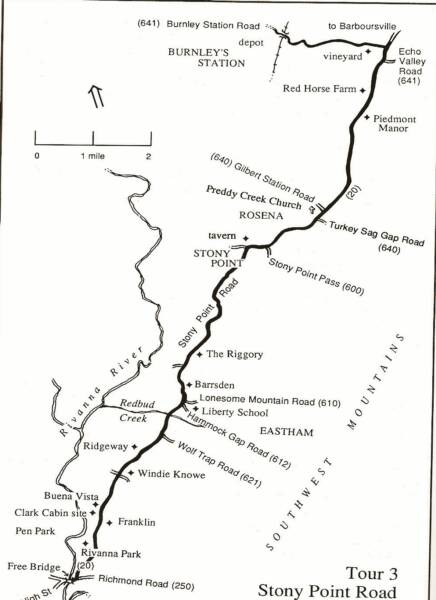
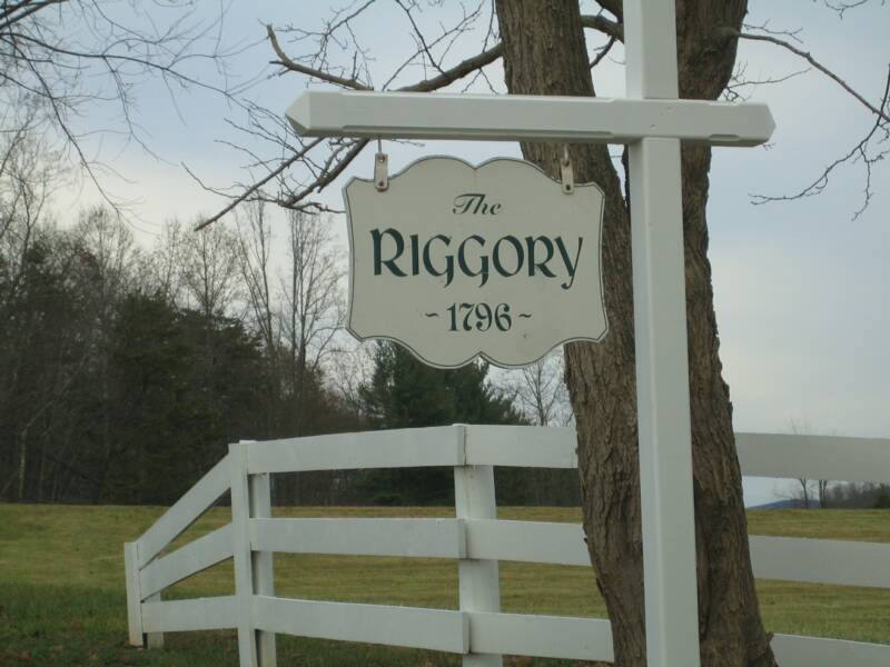
The Riggory: Right after you pass Proffitt coming up Route 20,
you'll see a beautiful farm on your right, with a lovely pond and
horses. Name after the fact that it's built on a stony spot, riggory,
it was built in 1796 by John Carr, it was first the
Franklin Minor classical boys' school through
the 1830s and then expanded in 1840 by Hugh
Minor. Also noted that it served as Philip
Sheridan's, Union General, headquarters
during the Civil War.
(although I haven't verified this as of yet).
Eastham Market: There used to be a general store, gas station and post office off Route 20, four miles up from Pantops. Built in the 1920s, it is named after an "old hamlet' that was located here around Redbud Creek (Near Hammock Gap Road). It was bought in the late 70s and turned into a residence.
Dovedale: Dovedale Farm is an example of a working family farm and was deeded in 1817. A long line of Shackelfords have worked the land and been laid to rest in the family cemetery there. A.C. Shackelford, 72, is the fourth generation to farm Dovedale - caring for cattle that are raised. This is on the right hand side, after you pass Route 600 towards Keswick/Cismont and on your way to Grand Junction.
Piedmont Manor: On the right, after Grand Junction, Piedmont Manor is a large estate, and according to our own Ron Smith, was the site of school for girls in the 19th century. Some of the scenes for the 1941 film, "Virginia" were also shot at this location.
Pinch-'Em Slyly: You've probably driven by this road a million times wondering what in the world does that mean....Well, I found out that this road used to lead to a 1792 inn that was torn down in 1827. It contained a tanyard and a tavern - and also according to an Albemarle County book written by a Reverand in 1901, a muster ground next to it where the militia company of the district performed their exercises. This area just on the west side of Stony Point, was called Barterbrook. The term Pinch'em-slyly is spelled differently in the various sources I looked at.
Jessies Lane is a road off of Doctor's Crossing. At this location, the McDaniel family had a very large farm at one point called Fairview Farm. Jesse McDaniel used to have fruit trees and sold corn that could then be milled down where Watt's Passage meets the railroad line/tunnel. Now you know why it's called Jessies Lane and to see what this area used to look like, click here.

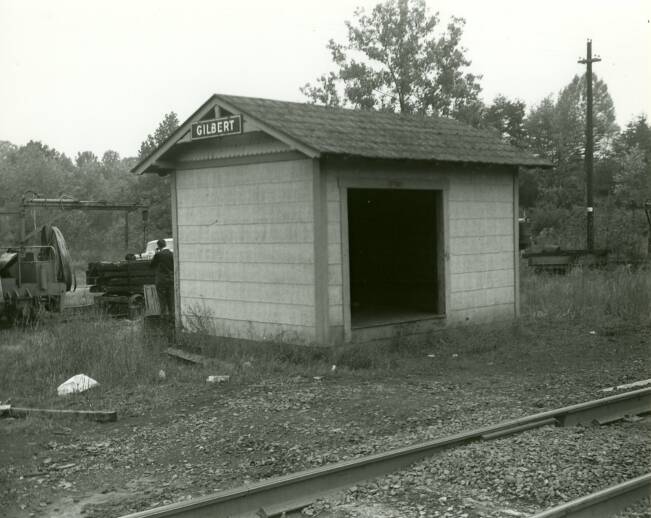
Old Gilbert Depot, near bridge on Gilbert Station